A winning challenge from Liverpool City Council has found an innovative satellite based way to help it sustainably manage and expand its tree canopy.
Mayor Wendy Waller said Canopy Manager has the potential to help one of the fastest growing local government areas in Australia meet its commitment to optimal environmental management. An emphasis would be on reducing urban heat island effect.
“The best possible living environment, integrating the proven benefits of trees and green spaces, is essential for the projected 60,000 more people who will call our city home in five years,” she said.
“Our population will grow to 300,000 people by 2030, with the number of households projected to grow from 75,500 this year to 126,000 in 2041. Additionally, Western Sydney Airport and its surrounding city begin operations from 2026.”
Facing such strategic challenges, council asked Australian research and development companies contesting US space technology company Maxar’s 2020 Spatial Challenge: How can high-resolution satellite imaging help it monitor its tree canopy and manage its desired ratio of green-to-grey infrastructure (this can include usually concrete structures at sewerage and other treatment facilities, and stormwater systems or storage basins).
The Maxar Spatial Challenge encourages collaboration to find new sustainable solutions to address Australia’s biggest challenges. In 2020 it drew 114 participants in 44 teams who used Maxar’s high resolution satellite imagery and platform.
Among them in the Urban Spaces category was Sydney based Spiral Blue, which took up council’s challenge.
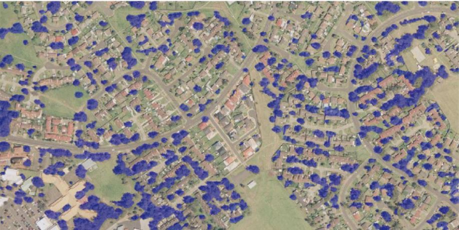
It developed Canopy Mapper, a prototype machine learning based process that can generate highly detailed representations of green tree canopy coverage in urban areas from satellite images.
Canopy Mapper can identify whether each pixel or dot making up a satellite image is part of a tree. The prototype is some 75 per cent accurate. It can produce tree canopy images of entire cities in seconds.
Spiral Blue CEO Taofiq Huq said: “We have a clear pathway to improving accuracy and adding features such as tree health analysis. It will enable users such as local governments to produce expert assessments of tree canopy coverage in a rapid and affordable manner.’’
Maxar’s earth imagery is used for applications ranging from helping industries and governments to conserve resources, expedite operations, ensure compliance and to even save lives.
“Canopy Mapper can be used for a wide range of applications by the council, starting from simple tree classification and mapping of the entire region to environmental protection of endangered plants,” it said.
Council will continue its evaluation of the technology.
Liverpool City Council’s partners in the project included the Australian Federal Government, the Australian Space Agency and Surveying and Spatial Sciences Institute.