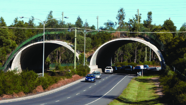
Just imagine two or three of these crossings along Appin Road, says local veteran environmental activist Pat Durman.
She says it would mean the local koala population and all the other native animals living on both sides of the road would have a safe crossing.
“And with really workable corridors across Mount Gilead with links to Beulah, Noorumba Reserve and the Nepean River they could continue to expand from the Royal National Park to the Blue Mountains,’’ Ms Durman told the South West Voice today.
Other crossings could be considered at Mallaty Creek, which is near Appin Road, and Ousedale Creek, which links up with the Nepean River.
“Surely this would be far better than all the bickering that is going on at the moment because all that is doing is creating bad feelings between the community and our local council,’’ says Ms Durman.
“Two koalas have now been seen in the Royal National Park and as you know there were three sightings in the Australian Botanic Gardens at Mount Annan

In the meantime vegetation of high and general ecological significance, including koala habitat, has been mapped out across the Campbelltown local government area (LGA) for the first time as part of a review of council’s Local Environment Plan (LEP).
Council endorsed amendments to the LEP at last Tuesday night’s meeting, to bring the planning document in line with the Greater Sydney Commission’s Western District Plan.
One of the key amendments was the inclusion of biodiversity mapping which used an LGA wide study of vegetation commissioned by council and data from other government agencies to better identify areas of significant vegetation.
“This mapping will ensure that ecologically significant vegetation, including important koala habitat, is woven into our core planning policies to facilitate their ongoing protection,” Mayor George Brticevic said.
“These changes are in line with the community’s vision for a green, sustainable city that is connected to its heritage and natural environment,” he said.
Updates to the LEP were also included:
- The formalising of a Scenic Hills Preservation Area map.
- Health objectives for Campbelltown.
- Increased building height limits for industrial zones.
- Rezoning of land at Western Sydney University to reflect current and proposed uses.
- Prohibition of sex services premises in the B5 Business Development zone.
- Conversion of deferred areas to the current LEP.
The LEP will now be forwarded to the Department of Planning, Industry and Environment to be formalised.